


Quick Adventure Facts:
Who - Joe (see gear list) & Mateo (see gear list)
What - The Tour du Mont Blanc
When - July 17th to July 26th 2015 | 10 Days
Where - French, Italian and Swiss Alps | map, .gpx, .kml *
Trail Overview
Trail
The Tour du Mont Blanc is a circuit around the Mount Blanc mastiff which passes through portions of France, Italy and Switzerland.
The TMB offers many official and unofficial variants. The average route length is approximately 100 miles.
TerrainThe TMB is a "tourist grade" trail, meaning it is very well maintained. There is no scrambling or particularly difficult terrain, but that does not mean it is easy. On the contrary, it is very physically demanding with long steep ascents and descents. If you have hiked the JMT or PCT you may find it similar to the High Sierras, in that you hike up up up to a pass then down down down to a valley, and repeat.
The TMB has a whopping 11,600 meters (38,000 feet give or take) of elevation gain. That means that on a 9.5 day hike like ours you are climbing 4,000 feet and descending 4,000 feet or more every single day.
Most people hike the TMB in the summer where temperatures routinely are in the 80's and afternoon thunderstorms are common. Even then, you are likely to find a little bit of snow near the passes and strong winds at the higher elevations.
Timing
The busy season for the TMB is mid July through August. If you hike it too early and there may still be snow on the passes, too late and you may get early winter weather. The downfalls to hiking it during the busy season are crowded trails and crowded refuges.
While the TMB doesn't have an official beginning or end, most hikers begin the TMB somewhere in the Chamonix Valley in France or in Courmayeur, Italy. Both locations are easily accessible via shuttles from Geneva, Milan or Turin.
The trail is very well mark and almost impossible to get lost on. Side trails usually lead back to the main trails and there are plenty of other hikers to refer to for help.
All the trail signs are in "hours" rather than km or miles. Don't underestimate how long this trail takes. It is only 100 miles or so, but it is extremely steep with massive elevation gain and descent every day.
If you plan to stay in refuges during the busy season it is a good idea to make reservations in advance
Camping is actually prohibited along most of the trail other than a few designated campsites.
ResupplyThere are "refuges" every 3-5 hours which are like hostels with bunkrooms. They have water, toilets, and sometimes hot showers. Most of them sell snacks and tasty beverages, and some have full cafes with cooked food. If you stay the night at a refuge they will usually cook you dinner and a light breakfast. They'll even pack you a picnic lunch to go if you want. All for a price.
The trail also passes through small mountain towns about every 2 days or so. They are ski towns which have resupply, lodging, and restaurants. You don't need to carry more than snacks.
If you are looking for a wilderness experience look elsewhere or choose a different season. Each day you may encounter hundreds of fit Europeans running circles around you wearing day packs or hydration packs. There is so much food and lodging that you can do the trail without even carrying a backpack if you want to. All the food stops can actually slow you down quite a bit since you are constantly stopping to eat and relax while you take in the views.
Water is fairly easy to come by, there are frequent mountain streams and every refuge has water. We never carried more than a liter or two.
Note: France and Italy use Euros. Switzerland uses Franks, but the Swiss locations on the trail took Euros without a problem. Many of the refuges don't take credit cards so bring Euros.
A typical 3 season set up like Joe and Matt used will work well on for TMB. You can check out Joe's gear list here and Matt's here.
Trip Report
By: Matthew Favero
With a wife and young daughter, I don’t have the ability to be gone for 6 months at a time. Only being able to get away for two to three weeks at a time really limits the types of trips that I can take. As such, I decided that I wanted to get the most bang for my buck and find trails that you could completely thru-hike in that time frame. Completing sections of a much longer trail little bits at a time doesn’t particularly interest me.
For me, completing the TGO Challenge in 2014 was an amazing introduction to hiking outside of the United States. While there are some great “short” trails in the US, there are some absolutely amazing ones all over the world too. Having answered customer emails for quite a while, I started compiling a list of the most compelling ones.
The one that kept standing out to me was the Tour du Mont Blanc. This 100+ mile circuit around the Mount Blanc Mastiff in the Alps involved crossing three international borders on foot. The views were supposed to be spectacular and the food, language and cultures were just as intriguing.
With Samurai Joe and our friend Steve on board, we jumped on an overnight flight to Geneva and we were on our way. When we landed, we grabbed a shuttle from the airport to Les Houches, France, where we’d begin our hike. When we got off the shuttle we were overwhelmed with intense heat. Europe was experiencing a heat wave and it was well into the 90’s.
We found a little market, grabbed our supplies, had lunch and then started the steep climb out of Les Houches. In hindsight, it might not have been a good idea to start hiking up such a steep trail in 90 degree heat at 2pm while jet lagged and with virtually zero sleep. Regardless, we did it anyway!
The climb was long and slow and not all the spectacular. The trail followed winding dirt roads with segments ducking into the forest where it shared tread with mountain bikes. Eventually, we reach a small ridge and follow towards a ski lift. There was a small restaurant where we took a break and stopped for ice cream.
Not long after we were back on trail, the views really started to open up. There was an expansive valley lined with snow capped mountains. It looked like something right out of the Sound of Music.
The trail slowly descended and crossed a sketchy suspension bridge over a raging glacier feed river before starting a nice little climb. The top of the climb dumped us out on a nice little plateau and we found a nice spot to set up our tents for the night. We’d later find out that this is, supposedly, illegal but we had plausible deniability at the time :)
The next morning we had a short climb up to Col du Tricot which gave us amazing views and, as we started hiking so early, some quiet time to share with the mountain goats at the pass. The decent down was long and relentless. It started to sprinkle as we made our way to the first refuge on the trail, Le refuge de Miage. We took a break, had some coffee and waited for the rain to break.
When it stopped raining, we made a small climbed that eventually leveled out and passed a shrine and a couple more refuges before dropping into the village of Les Contamines. The small village was vibrant and full of life and we took the chance to enjoy some of the local Savoy fare.
After lunch we continued down heading up the valley as the heat began to really beat down on us. We stopped to swim into a glacially fed lake. The water was ice cold, we ran and jumped in and the cold took our breath away. We could only stay in the water for a few seconds before having to run out.
After the lake, the trail passed an old church and then started a slow and steady climb up the valley. Before long, there were pastures on both sides of the trail full of huge cows with giant bells. You could hear the ringing from what seemed like miles away. It took awhile but you eventually get used to the ringing and barely notice it.
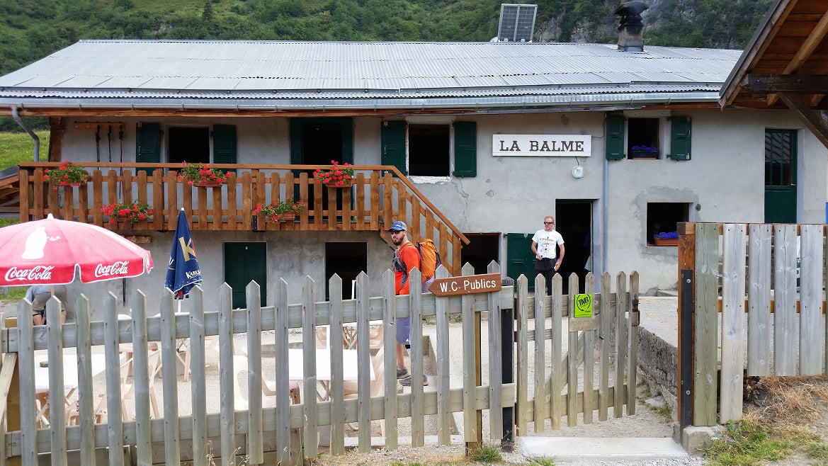
In the distance, we could see that the trail was about to start really climbing. Just before the climb we came to Refuge La Balme and decided to call it a day. Our room was an “alpine style” bunkhouse which means one long bed with no breaks. Our room had a double level bed.
The refuge had an awesome little dining area outside and we enjoyed snacks and drinks before taking a nap. Dinner was pretty good too and talking with the other hikers from around the world was really enjoyable.
The next day, we began the steep climb up to Col du Bonhomme. After the pass the trail ascended at a more reasonable pace and we started making good time. We stopped for a break and some cake at Refuge de la Croix Bonhomme before making the decent to Les Chapieux.
Here the trail takes a sharp turn and follows a river up a valley. You pass a WWII memorial for the French soldiers who fought against the Italians (the Italian border is just to the east.) The trail is on a paved road for a few miles before becoming a dirt road.
Steve and Joe were a little ahead of me at this point and as we were approaching the next refuge, Refuge des Mottets, I was hoping that they were going stop there for the night but, instead, they followed the trail upwards towards the Italian border. The climb seemed to take forever, probably due to the fact that I wanted to stop at the base of the mountain. We took a break when we finally made it to the pass before making our way into Italy.
The trail immediately started to decend down the other side of the pass and we had our eyes out for the next refuge or a great campsite. We saw a building in the distance and got very excited thinking that we were about to come to another refuge. When we arrived at the building it turned out to be a refuge for a nonprofit organization and not one open to the public.
As soon as we were out of sight of the refuge, we found a flat piece of land and set up our tents for the day. It had been a long day and I was exhausted. I scarfed down some food and quickly passed out.
The next day I woke up early and was restless. I packed up my gear and hit the trail before the others. The views were beautiful and I got a glimpse of my first marmot. I continued down the valley as it slowly mellowed out and soon spotted the first rifugio in Italy, Rifugio Elisabetta.
People were still eating breakfast when I went inside and made my way to find some snacks. I was stoked to find a small can of Pringles and brought them to the check out. The girl at the register looked an me for a few seconds before saying “hola! It turns out that she was trying to figure out where I was from so that she could great me in the appropriate language. I replied “You thought I was Spanish” to which she nodded.
I went outside to eat my Pringles and wait for Joe and Steve and discovered a WWII memorial to American Paratroppers who lost their lives in a battle for this area. It was humbling to be in a place with so much history and beauty and to stumble upon a monument dedicated the Americans who made the ultimate sacrifice in WWII.
Joe and Steve eventually caught up and we hiked alongside an old Roman road before beginning another climb. The climb was tough but provided us with amazing views of the beginning of the Aosta Valley.
When the trail finally started to descend we came upon Rifugio Maison Vieille. The rifigio was rustic and full of life. There were a ton of tables full of people eating lunch and we decided to join them. Our waitress talked with the stereotypical speed and hand movements of an Italian and it truly felt like we were in a different country than the day before. The carbonara was the best that I’ve ever had.
We took a ski lift down from the rifugio into Courmayeur. This is the only city or village that the TMB passes through in Italy. We checked into a hotel, resupplied and explored the city streets. It was nice to get a little glimpse of Italian city life. We headed back to the hotel, had an awesome meal and then went to sleep.
Our last full day in Italy began with a super steep climb as we left Courmayeur. A series of never ending switchbacks guided us the mountain. The amazing views helped distract us from the climb and the heat. Just before the climb was over, we came to Rifugio Bertone. The rifugio is pretty small but the views are sick! We took a break and had some snacks before continuing on.
Shortly after leaving the Refugio, the trail split. The old TMB route headed up to the ridge and the new route wrapped around the mountain. I wanted to stay on route and Joe and Steve wanted to climb up here. We decided to split with no real plan on how or where to meet up.
As soon as I left them, the trail quickly curved around the edge of the mountain and flattened out. For miles, the trail was gentle and the views were nothing short of spectacular. Separated only by the narrow Aosta Valley, the back side of the Mount Blanc Mastiff was almost at my finger tips. Jagged rock and snow covered peaks dominated horizon.
It was hot but I was making really good time and a few hours laters I had made it to Rifugio Bonatti. I went inside to get a drink and laid on the ground outside waiting for Joe and Steve. After waiting for an hour, I assumed they were ahead of me and I made my way down the trail.
Thinking I was behind them, I turned up the pace. I was really moving as the trail took me down into the valley and followed alongside a river. Then the trail started to climb. My pace, the sun and the long day had begun to take its toll on me. I was struggling.
It felt like it took me 2 hours to hike the last 3 miles. My pace slowed to half my typical speed and I staggered into Rifugio Elena tired and hungry. Joe and Steve weren’t there! How were they so far ahead of me? Maybe I was ahead of them? I sat on the balcony waiting for them to come. As the sun set and they failed to appear, I was convinced that they were in front of me.
After the sun set, I went inside to eat dinner but I had pushed it so hard during the day that I was dehydrated and nauseous. I simply could not eat. I sat there and nursed a coke before giving up and going to bed.
When morning came, I could still not eat. Undeterred, I drank as much water as I could and hit the trail, intent on catching up with Joe and Steve. The climb out of Rifugio Elena is a long and steep one. It didn’t take 15 minutes before I began to struggle. I started asking people who were passing me if they had energy gels. My begging didn’t end favorably.
Slowly, I made my way to the Swiss border and my climb ended. Once the trail entered Switzerland, it was a long slow decent. I began to fly and my spirits rose by the minute. I was moving fast and I was envisioning catching up with Joe and Steve at any time.
I soon came to a valley and followed a river as it wound its way down. Eventually, I found myself in the village of La Fouly. Joe and Steve had to be here. I went into a small market and stumbled upon a glorious site; Arizona Green Tea! A glimpse of home. I pounded two teas, ate an ice cream and then devoured a sandwich another hiker offered me. I was back!
While I may have found my energy, I did not find Joe and Steve. How were these guys still ahead of me? I was going to have to do the thing that hikers dread the most, skip a section of trail to keep up. I hopped on a bus, skipped a couple hours of trail, and headed to the next town, Champex Lac.
The bus ride up to Champex Lac was full of sharp turns and scary cliffs. It was pretty exciting and I had a blast watching everyone freak out. The bus dumped me out in the heart of town and I immediately began looking for wifi.
I asked a group of teenagers if they knew where I could find some wifi and they looked at me like I was crazy. I took out my phone and made the motion like I was using it to browse something and they say “Oh We Fee.” Embrace the culture right?
When I finally found wifi, I logged into WhatsApp to see if Joe had sent me a message. No luck. Maybe I was ahead of them? Who knows? I decided to get some snacks and sit on a bench along side the lake and take in the beautiful view.
I took a swim, watched a movie on my phone and keep checking my messages. Finally, a message from Joe. “Where are you?” “Having Ice Cream in La Fouly.” What?!? I was ahead of them this whole time. I couldn’t believe it. “When do you think you guys will be in Champex?” “By 7pm.” “See you then.”
I had 4 hours to kill before they were going to show up. I watched another movie, walked around and tried to keep myself busy. 7 came and went and there was no sign of Joe or Steve. When 8 o’clock came, it was time to eat. I found a little restaurant, ate a delicious cheeseburger and waited some more.
The sun set and it started to rain. I had to try and find a place a stealth camp. The entire village is surrounded by steep mountains and the buildings are built into the hills. I wandered down every back road and path I could find and could find a single flat spot to find.
Eventually, I found a spot behind a broken down camper backed up to.a fence behind a hotel. In the rain, I set up between the camper and the fence. I set up my tent in the rain and tried to get some sleep. Little did I know, I had set up right on the other side of the hotel garbage cans. Late into the night hotel staff kept coming out and dumping their garbage a few feet from my head. Fun times hiker trash style!
When morning came, the rain had stopped and I packed up my gear. I made my way down to the same bench that I had occupied the day before and began to wait once again. The hours clicked by and finally at 11am, Joe and Steve appeared. We had a laugh about our time apart, ate lunch and then hit the trail; together once again.
The trail followed a quiet valley for quite a ways. Passing by the chateaus, I couldn’t help but think that this would be an amazing place to disappear to. We continued on small paved roads the gave way to gravel ones before ascending up the side of a valley.
The trail crossed a river and continued to climb before leveling out and wrapping the contour of the mountain. We passed a bunch of cows, bells ringing, before stopping for a snack at a small hut along the trail.
The trail climbed briefly after our snack before starting a long decent. During one section, we had to walk around large cows standing directly on the trail. They were unfazed by our presence and their size was a little intimidating.
The trail spit us out next to the Hotel Forclaz and we decided to stop and eat at their restaurant. There was a cheeseburger special and I asked the waiter “are they good?” With pride, he asked us “do you know those cows up on the mountain?” Having passed them just a couple of hours early, we acknowledged that we did. “It’s thoossee cows,” he said. The burgers came out and we feasted upon them. They were so good, the best burger I’ve ever had. I highly recommend them!
After our meal, we made our way down to the bottom of the valley into the small village of Trient. We passed through the old churches and buildings and ducked into the woods to find a place to set up camp. After following an old forest road, we found a nice flat spot tucked into the trees and called it a day.
In the morning, we made our way back to the trail which began with an easy stroll along the bottom of the valley. Soon the trail began a long, steep, climb up towards the French border. The climb made its way up through lush forest before entering a rocky, treeless, section for the last part of the climb.
The views from the border are some of the best on the Tour. Long, unobstructed views of the Chamonix valley stretch for as far as the eye can see. Snow capped peaks dominate both sides of the valley. A ski-lift services the valley to bring tourist to the top for the spectacular views. We took a break and grabbed some drinks and snacks from the refuge at the top before continuing on our way.
From the border, the trail wraps around and up to the ridge on one side of the valley. The hiking is rocky but they views are too distracting to notice. Before long, the trail descends to a pass. From here, you can climb back up the other side or take an alternate route into Argentière. Another hikers description of the food in Argentière, made our decision easy.
A half hour later, we found ourselves at a British Pub eating burritos. No, that wasn’t a typo. After lunch, we found a hotel, checked in and took a nap. When we woke up, Joe was throwing up from food poisoning but Steve and I were feeling good. Steve and I went out and found a nice little pizzeria and had a great meal before heading back and calling it a night.
The next morning was to be our last. We continued along the alternate route following along the valley floor following beside the Arve River. The trail was mostly wooded and the hiking was tourist grade. A couple of hours later we enter of the town of Chamonix.
Chamonix is a beautiful little tourist town surrounded by the majesty of the Alps. Home to the first Winter Olympics, Chamonix has solidified its place as a skiers paradise. The city streets are filled with high end shops, tons of restaurants and thousands of tourists; just like us.
We had soon left the city and found ourselves once again besides the Arve as it continued its journey to Geneva to meet up with the Rhône before finally emptying into the Mediterranean just west of Marseille. The views are amazing and the trail was gentle and easy as we made our way through lush forest on the north side of the river.
Soon we found ourselves back in Les Houches, having successfully completed the Tour. Hiking in this part of the world had been truly life changing. The views, culture and food were all unbeatable and the hiking was an absolute dream!
*All provided navigation files are made available as a planning resource with the understanding that data is provided with no warranties, expressed or implied, concerning data accuracy, completeness, reliability, or suitability. Zpacks shall not be liable regardless of the cause or duration, for any errors, inaccuracies, omissions, or other defects in, or untimeliness or unauthenticity of, the Information, or for any delay or interruption in the transmission thereof to the user, or for any Claims or Losses arising therefrom or occasioned thereby. The end user assumes the entire risk as to the quality of the data.
